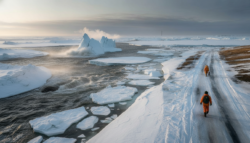
The wind hits you first. You stand on a strip of land that doesn’t exist on any old map, and the wind is cold and salty, blowing straight off the North Sea. A perfect line of new dunes rises like a quiet wall to your left. Cows are grazing behind a silver canal to your right. It looks like this piece of land has always been here, and it has always been Dutch. A fisherman in a blue jacket points with his cigarette to a calm lagoon behind the new dike. “River used to go straight there,” he says. “Now it curves. We bent it.
How a flat country made rivers move like chess pieces
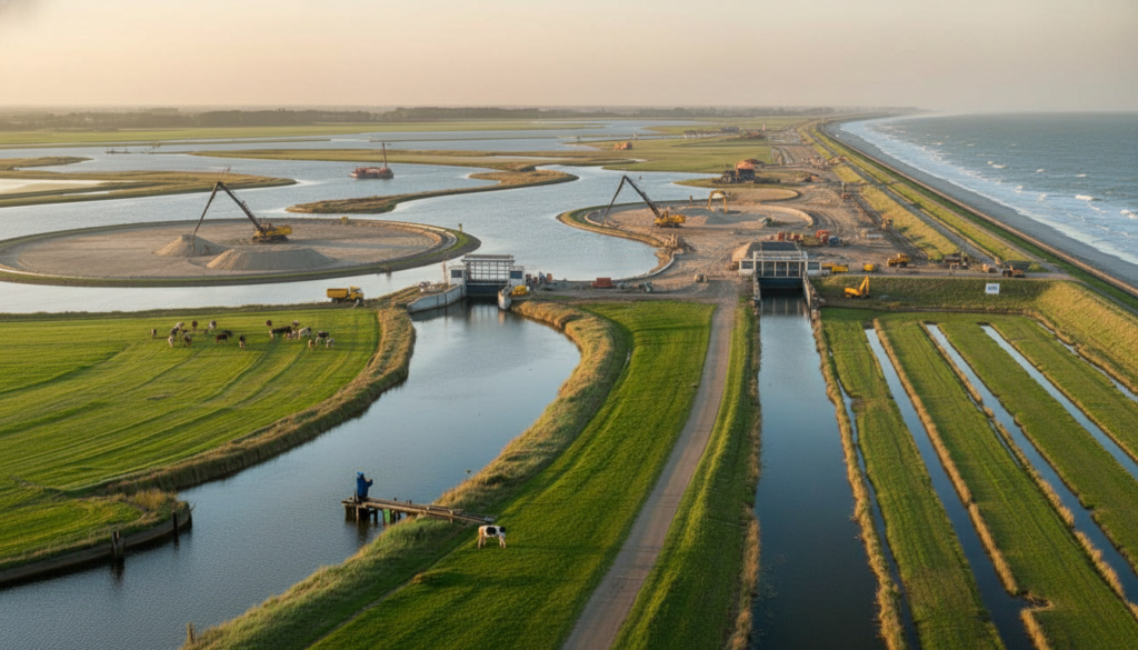
Satellite pictures make the Dutch coast around the Rhine–Meuse delta look like it has been edited. River mouths that used to go straight into the sea now curve, get wider, split into lagoons, and then slip out through narrow gates. There used to be open water, but now there are huge sandbars. Old estuaries are closed off.
Behind those small curves is a bold truth: for more than ten years, Dutch engineers and farmers have been agreeing to pull, push, and sometimes cut off whole branches of rivers. Not just with harsh concrete, but also with small changes, detours, and kilometres of new channels cut through fields that used to grow tulips and potatoes.
The “Room for the River” program started after floods in the 1990s that almost caused a disaster. At first, it sounded like a poetic phrase. In practice, it meant something radical: moving levees inland, cutting new side channels and even lowering floodplains so that rivers could spill out in a controlled way.
Farmers in the IJssel valley saw diggers open a new branch that sent some of the river’s power sideways instead of straight into the North Sea. You lost a piece of farmland and got a safer, calmer water system in return. Ten years later, that diversion lets technicians send less water violently out to sea, which moves sediment and energy into protected basins where new land is slowly forming, grain by grain.
This is how the Dutch do it: they use rivers as tools, not just threats. When a river hits the ocean at full speed, it wears away. When you split and slow it down, silt falls out and starts to stack up. Over time, enough silt turns into marsh. With the addition of dunes and planted grasses, marsh becomes a living barrier and, eventually, land that can be built on.
The Netherlands has been teaching rivers to do hard work for free by changing their flow into wide, shallow areas and back lagoons. Coastline “defence” and coastline “production” are the same thing. And that quiet change has begun to change the map.
The delicate art of taking back land as the seas rise
The Dutch no longer just talk about fighting the sea; they also talk about working with it. “Building with nature” is the one exact method that makes up this strategy. Engineers design bent river mouths, permeable barriers, and strategic diversions that trap sand and silt right where they want new land to grow, rather than hard, straight dikes all over the place.
Near Rotterdam, river branches have been changed so that less water hits the estuary gates directly during storm surges. Some of the flow goes into wide side basins, where the currents slow down and the sediments settle. Years ago, plans showed those basins as empty blue areas. Today, they are covered in reed islands and young dunes that look like natural armour along the coast.
On paper, it sounds like a medical procedure. It’s messy and emotional work on the ground. Families watch as old river views fade away. A farmer whose fields used to touch a straight canal now has to watch a wide, slow-moving side channel grow across what used to be his best pasture.
We’ve all been there: a big “public good” project quietly goes through your backyard and asks you to give up something important to you. The Dutch government found out the hard way that you can’t just put a new river line on a map and expect people to like it. So talks go on for years. Money comes in. A wet basement or a lost fishing spot are small mistakes that leave scars that no amount of polish can fix.
In a meeting room in Zwolle, one government worker shrugged and said what the new approach was all about.
“We stopped pretending we could freeze the coast,” she said. “Now we control it. A little to the left and a little to the right. “Slowly.”
That way of thinking affects many local choices, even ones that people on vacation might not notice when they look out at the sea. A few simple rules are behind them:
Change the course of river branches so that high flows are spread out instead of piling up at one outlet.
Don’t let sand and silt float away; instead, use wide, shallow basins to catch them.
Before putting up concrete walls, let new marshes and dunes grow.
Some farmland turns into water, which lets other land rise from the water.
Keep making changes; every storm and flood gives you new information for the next one.
What this quiet revolution on the coast really says about us
When the tide is low, the whole place hums with paradox. This ground exists because someone convinced a river to turn ten degrees years ago. The houses look normal. The parking lot at the grocery store is half full. Kids ride their bikes home from school along a path that used to be a riverbed but is now a neat canal with wildflowers on the sides.
From the air, it’s a work of art based on data. It’s just life going on, on land that used to be sea.The story really lives in the space between the spreadsheets and the muddy boots.
| Key point | Detail | Value for the reader |
|---|---|---|
| River diversion as a slow tool | Redirecting branches spreads flow and deposits silt in controlled zones | Shows how long-term planning can turn a threat into a resource |
| Building with nature | Using dunes, wetlands and lagoons instead of only hard dikes | Offers a model for climate adaptation that feels less like war, more like partnership |
| Quiet human trade-offs | Farmers, fishers and residents give up pieces of land or habits to gain safety | Helps understand the real social cost behind “smart” climate solutions |